
When a literary agent sends a novel manuscript out to acquiring editors at major publishing houses, s/he likes to send it with everything the editor might need to put the work in context. For Hild, my novel about Hild of Whitby (which of course wasn't called Whitby then), set in early seventh century Britain (the narrative spans 617 - 631 CE), this includes a map, a glossary, and a family tree for the main character/s.
I've spent the last two weeks happily constructing this supplemental material. You've already seen Hild's family tree, along with all my questions and caveats. Today it's the turn of the maps.
I've included three: my first draft attempt, the second iteration made with help from a scientist friend who downloaded GIS data, and the final (so far) representation which collates data from several stages and was polished by a friend who has mad Photoshop skills. If you only have time to look at one, look at the last one.
You can see a much bigger version of each map if you click on it.
So. Map Number One:
I think of of this as my sketch map. I made it by brazenly scanning a map from the endpapers of someone else's book (I will certainly buy the author a drink given the opportunity) and then scrubbing out the names and replacing them with my own (by the squint-and-point method--no claim to accuracy at this stage). This is where you see how sadly lacking I am in Photoshop skills. (Though my Anglo-Saxon Twitter icon might have been an early giveaway.) I hadn't the faintest idea how to make something that looked like a wall, so I just drew a thick line, then 'bit' chunks out of it with dabs of the Brush tool. I used the same tool to dab in the dots for vills and other settlements. And to create Puffin Island/Glannauc, just off the eastern tip of Anglesey/Mon.
Glannauc makes an appearance in the book. More on that later.
But this first map was never intended to be anything but an initial sketch map, a for-personal-use-only building block for the real thing.
For the second map, a friend in New York worked her academic institution's servers half to death to bring me a true projection of Great Britain, complete with relief features. I sent her the sketch map, and coordinates of anything that might be misconstrued (for example, Derventio--see below) and the names of the rivers I needed. She sent me this:
You'll see that there are one or two made up names, too, for example Mulstanton, which is a settlement on the River Esk, below the cliffs of the Bay of the Beacon/Streanæshalch/Whitby (the spellings get fixed in the next iteration). As for Derventio, I plumped for a place close to an old Roman villa, at Malton. (Yes, I know there's another Derventio near Derby, but I wasn't interested in that one, story-wise.)
But I found this map difficult to read. And it still needed territories/peoples adding, and walls, and so on. And I needed more room. So I cropped it to the size I needed, and begged for help from a photographer friend.
This is what we came up with: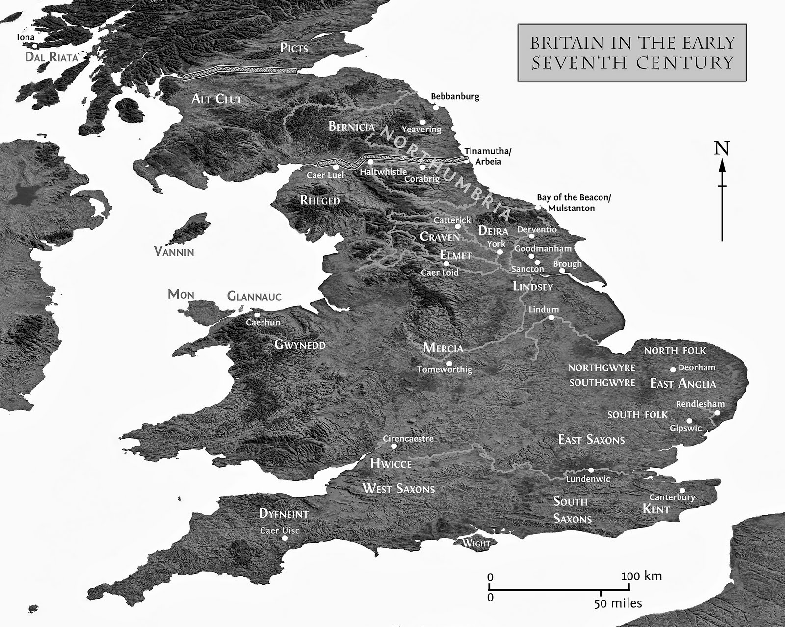
If you click on the map, and then zoom in, you'll see that there are actually two Glannaucs: the tiny one is the real one. The big one right next to it is purely imaginary. I just needed the reader/editor to be able to see it. That'll get fixed for publication. So will the relative sizes/fonts of the various peoples and their regions. For this iteration my priority is for editors to be able to find a region on a map quickly, so they didn't have to go look things up and get bumped out of the story.
You'll also see that there's a lot left out. I was ruthless: if it wasn't in the story, it's not on the map. As it is, there are some Irish places, and some non-British locations (Hedeby, Frankia, Less Britain) that are mentioned in the story but not included here for the sake of clarity and simplicity.
If you see something you don't agree with, please let me know--either by email or in a comment. I want to get this right.
I'm hoping I can do the final map for the book in colour. I'm hoping I can do an absolutely enormously detailed map for the website I'll build to support the book closer to publication. I'd love to illustrate tiny little scenes from the book on this enormous map, and include tokens/banners/signs of dynasties/peoples on their region (ravens, boars, bulls, eagles).
What else have you often wished authors included on their maps? Tell me what you'd love to see. Please.
Many thanks to Angélique and Jennifer for their labour of love. Good friends, both.
